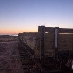
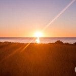
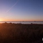
As I’m sure you know by now, we’ve been waking up quite early, and today was no exception.
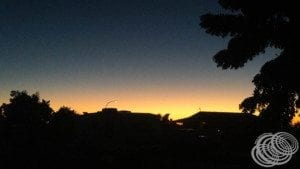
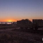
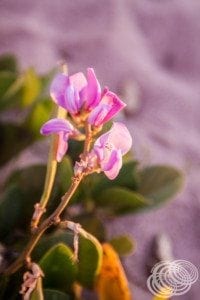
We had a beautiful morning to see, and the beach is just across the public car park from the caravan park, so we had the perfect location to get some beautiful sunrise photos.
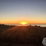
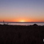

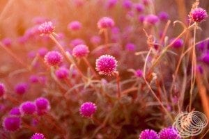
Then, of course, there are the wildflowers at the beach that looked stunning with the morning sun on them.
On day eight we travelled from Point Samson to Exmouth, going via Karratha and Dampier. It’s 633km’s, but by the time you go into Wickham, Cossack, Roebourne, Karratha and Dampier, the time does start to add up, so we didn’t get into Exmouth until just after dark.
On the way out of Point Samson, we went around the opposite side of the point to where we came in and saw Honeymoon Cove Beach.
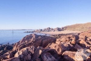
It’s a beautiful little cove and beach. The beach itself is a bit rocky, but it looks like a great spot for a swim. From the beach, you can look out towards Jarman Island which stands out quite prominently due to the lighthouse located there.
Point Samson-Roebourne Road is the only road in and out of Point Samson, and you have to go back to Roebourne to continue to Karratha, so that’s the way we went. Along the road are two small towns, the newer mining town of Wickham, and historic Cossack.
Wickham
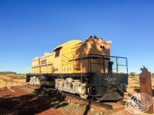
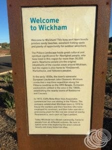
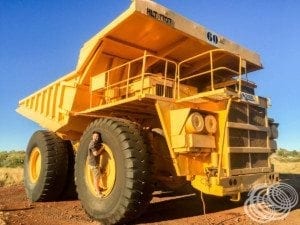
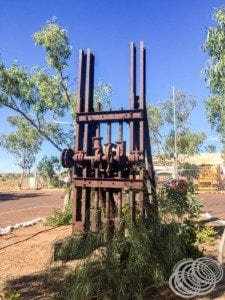
Wickham comes first, so we went in to see it. At the turn off onto Wickham Dr, the main road into town, there is a friendly mining welcome from Rio Tinto with a retired Robe 170-tonne mine haul truck and Robe locomotive along with a heap of information about the area.
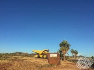
It’s full of information with signs sharing history and information about the town.
After 2008 it was modernised with the addition of the mine truck, bitumen carpark and lots of new signs.
Wickham itself is a combination of an old and new town.
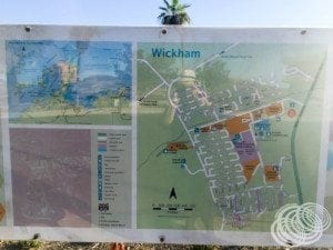
One-half is older buildings that must date from the first mining settlement there in 1970 by the Cliffs Robe River Mining group.

The other half of the town has buildings that look almost brand new. While it is part of Roebourne Shire, Rio Tinto owns a lot of the land and buildings so I’d say they are newly built to support the mining operations there.
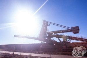
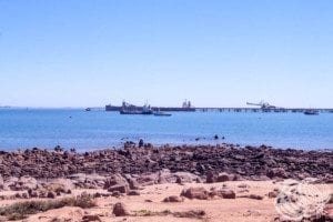
Out the other side of town at Cape Lambert is Port Walcott, an Iron Ore loading facility.
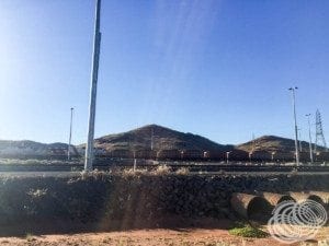
While you cannot access it to see the jetties that are meant to be some of Australia’s longest and tallest, it is rather awesome to see the massive machinery in operation. The closest you can get is by following Boat Beach Road out to the Wickham Yacht Club.
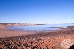
Once you get down to Boat Beach, you can’t see the mining operations at all, but do get a good view of the beach. It also turns out that if you are visiting between October and April, you can apparently see turtles nesting and hatching.
The map looks like the public may be able to take Cape Lambert Rd on the other side of the port, but we didn’t have time to see if you actually could or not. It’s important to note when looking at this area that a lot of the roads are private roads. So even though they are there on the map, they aren’t necessarily accessible.
cosaco
Heading out of Wickham, it’s not far to the historic town of Cossack.
Cossack was first called Tien Tsin Harbour, and many of the original buildings remain even though the 1950’s saw it abandoned.
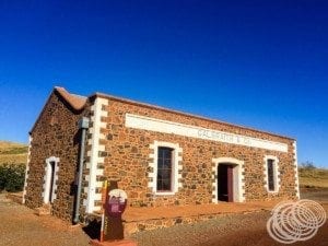
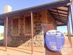
You can find the old customs house, telegraph office, Galbraith’s store, police lockup and the courthouse.
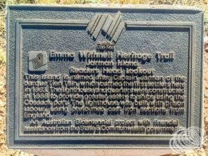
The town was founded in 1871 and was the birthplace of pearling in Western Australia before it moved to Broome in 1886. The old courthouse is now a museum and information centre, and throughout the town, you can find signs following the Emma Withnell Heritage Trail with information about the buildings and points of significance.
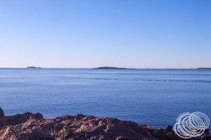
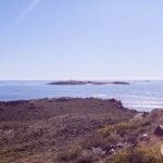
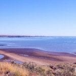
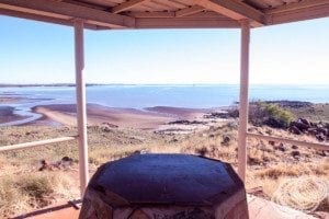
Heading out of the town towards Reader Head on Reader Head Rd you can either go to Settlers Beach or out to the head itself where the Reader Head Lookout is located.
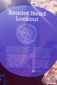
The lookout is located at the top of a hill and offers 360-degree views of Cossack, Cape Lambert, Settlers Beach, Point Samson, Jarman Island and Butchers Inlet.
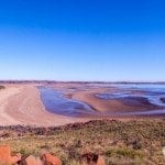
It is gorgeous in its own unique way, and the compass is very helpful for getting your bearings and identifying the landmarks you can see.
We were there too early to check out the museum and since it wasn’t open we decided to keep moving. It would have been nice to see what was inside, but we needed to keep going anyway.
Roebourne
From Cossack, we made our way back to the town of Roebourne.
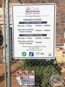
Unfortunately, we still got there too early for the visitor centre to be open! During the time we were there on the weekend, the opening hours were 9 am to 3 pm. It’s worth noting as it does open later and close earlier than some other visitor centres, and it doesn’t open on weekends at all during the wet season.
We took some time to have a look around from the outside and then got going.
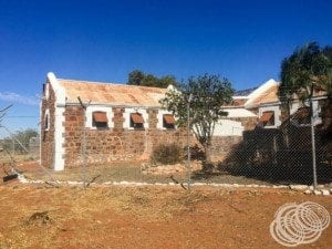
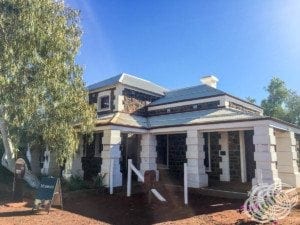
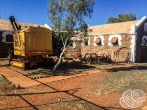
The visitor centre is actually in the old Roebourne Prison, which is a good example of the old architecture.

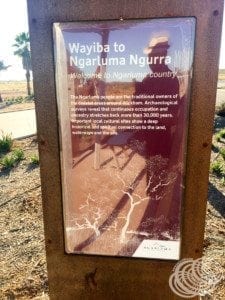
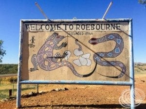
Some of the signs told us that Roebourne was founded as a town in 1866 in the traditional country of the Ngarluma people.
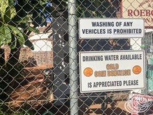
It’s the first visitor centre where we found access to a drinking water hose, available to fill up your water tank for a gold coin donation regardless of whether the visitor centre is open or closed.
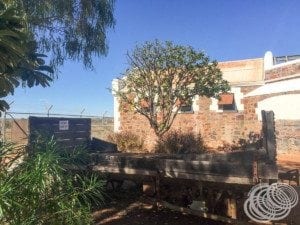
Inside the visitor information centre is also a museum with a $3 entry fee. We couldn’t check it out, but looking through the fence at what is inside the prison grounds makes one think it could be an interesting combination of Aboriginal, pearling and mining history.
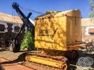
Within the fences, and in the carpark, you can see retired Robe mining and rail equipment while the signs are decorated with local Aboriginal artwork.
Ironically, just as we were pulling out of the carpark, it ticked past 9 o’clock, and the front door to the old gaol opened.
On the way out we noticed a sign pointing to the Mount Welcome Lookout, so we decided to check it out. It is at the end of Fisher Road, which is a bit steep and narrow in places so I would advise taking it slow and carefully. The lookout is at the top, and you can drive the whole way on a bitumen road. Once you get there, you will find iron sculptures that, from what I understand, represent the different Aboriginal peoples from the surrounding areas that were all brought together in Cossack as pearl divers.
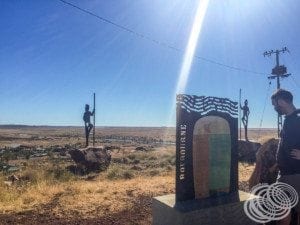
The mountain itself got its name because it could be seen from the ocean where the Withnell family first landed.
Karratha
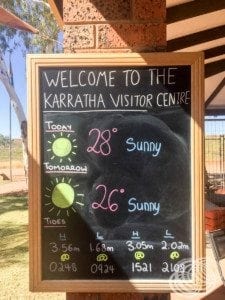
After carefully making our way back down from Mount Welcome, we headed out of Roebourne towards Karratha. It’s only 40km’s from Roebourne to Karratha, so an easy half-hour drive. The visitor centre is on the way into town on De Witt Road, so we stopped in for some information.
We had not come across much to do here that didn’t involve unsealed roads or hiking, so we thought they might be able to give us some advice. Unfortunately, they couldn’t, besides going out to Dampier, everything involved unsealed roads or hiking. One thing to note though is that campsites in all the national parks now require online booking rather than just turning up. So you do need to book in advance.
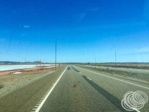
Since there wasn’t a lot to see, we went for a drive around the town, and it turns out that with all the mining operations, it is quite modern. While there are old sections, much of it has been done up, and it has pretty much everything you could want from a town, including a cinema and a decent range of shops. Without much else to do, though, we fuelled up the van and headed through the salt flats towards Dampier.
Más húmedo
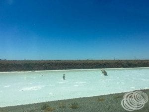
Dampier is famous for two reasons. The first is Dampier Salt, and the second is Red Dog. You have to follow the Dampier Highway through Karratha and across the salt flats to get to Dampier itself, and along the way, you get to see a lot of the salt production facilities.
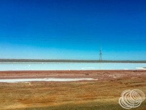
The salt is so thick, it almost looks like snow, and the salt man seemed to suggest we weren’t the only ones that thought so!
On the way into Dampier, you will find the information bay and a statue of Red Dog.

For those that have never heard or Red Dog, he’s a bit of a legend in Australia. I don’t know how much of it is true and how much is hyperbole, but you can read a bit about him on Wikipedia, or check out the 2011 movie, 2016 movie, or one of the three books about him.
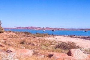
Onwards into Dampier, there isn’t much else there besides the yacht club, a caravan park and some houses. You can, however, get some great views along the Esplanade looking towards the nearby islands and the Dampier port facility.
Exmouth
After leaving Dampier, we headed on down to Exmouth.
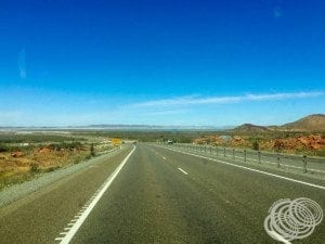
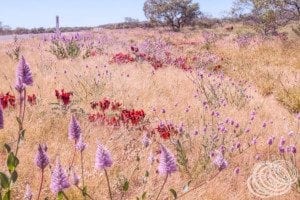
Being 555km’s, this is the longest trek for the day. It takes almost 6 hours to drive after taking stops into account. There isn’t a lot to see, but there was an abundance of wildflowers along the road, including masses of Sturt Desert Peas.
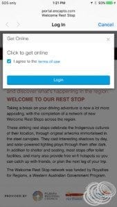
There isn’t much to stop at along the way except for roadside rest stops, however, these stops are not your usual rest stops. We stopped at a couple of them, including this one at Robe River in Kuruma Marthudunera country.
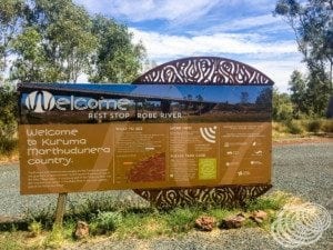
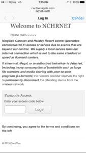
The stops themselves are great because they have so much information about the area and thing to see, but they also have free wi-fi available!
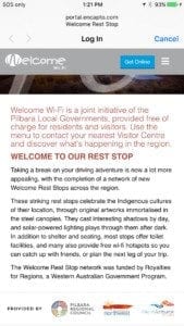
All you have to do is agree to the terms of use, and you can jump on the wifi.
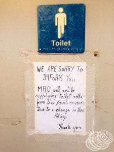
Do be sure to take toilet paper though, because even though there is free wifi, not all of these rest stops provide toilet paper.
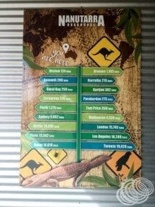
A little further on we stopped at Nanutarra Roadhouse to fuel the van up which gave us plenty of fuel to get out the peninsula to Exmouth near the end of North West Cape.
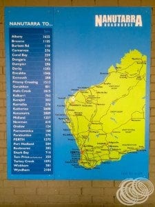
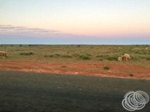
There is also another roadhouse near the turn off from the North West Coastal Highway onto Burkett Road to Exmouth if you need it. It is still 165km’s from the turn off to Exmouth, and then there are the surprises along the way. After you turn on to Minilya-Exmouth Road, a significant portion is unfenced sheep grazing. We were coming through Learmonth just on dusk when we realised that there were no fences and so sheep were near the road. It wasn’t long before we found them on the road, so you’ve got to be on the look out for them.
It was about 7:15pm by the time we got to Exmouth and after dark. There are two caravan parks in Exmouth that we were considering. We thought the Ningaloo Caravan and Holiday Resort looked like the better of the two when we were looking online, so we decided to go there.
There are a few caveats to be aware of with Ningaloo Caravan and Holiday Resort. While it was $49/night for a powered site when we stayed there, if you are arriving outside of reception hours, there is a late arrival fee of $5 per site. Cash is also the only accepted payment method. If you don’t have the correct amount of money, you can get your change in the morning when the reception office is open. If you need $54 (like we did since we arrived late) and all you have is two $50 notes, then you will have to pay $100 and get your $46 change in the morning. It sucks if you want to leave early in the morning, so if that’s your plan and you want to stay here, make sure to check their sitio web for current tariff’s and ensure you’ve got the right cash.
While the correct cash only system is a pain, especially in this day and age where you can process credit cards with a smartphone, it isn’t the most annoying thing about a late check-in. You have to use a phone outside the reception office to call the after hours staff. Not a big deal except that the phone doesn’t work properly. It calls, but apparently, they can’t hear you at the other end, so we had to call a couple of times before the person on the other end decided to just come down to reception. It seems like a crucial thing to work properly. Then when they came down to reception, they said they knew it wasn’t working and it hadn’t been for a while. So if they knew, why didn’t they just come straight down to reception when it rang, why hadn’t it been fixed yet, and why didn’t it have a note up about it not working properly?
We did finally get in though and were given an ablutions key and wifi access code. The free wifi is a nice touch, but it is very slow.
The ablutions are relatively new and well maintained while the sites were fairly level and spacious enough that you weren’t on top of all the other campers. The campground was quite full the night we were there, so we had a choice of only two sites, meaning the spaciousness of the sites was noticeable.
So we made ourselves some dinner and got to bed with plans for a big day of snorkelling in Ningaloo National Park the next day!

